
If you love the great outdoors, camping and learning about Aboriginal history, then this self-drive tour is for you. Less than 3 hours north of Sydney is Hawks Nest, a popular coastal town well known for its outdoor recreation activities, breathtaking scenery, sun-kissed beaches and wildlife.
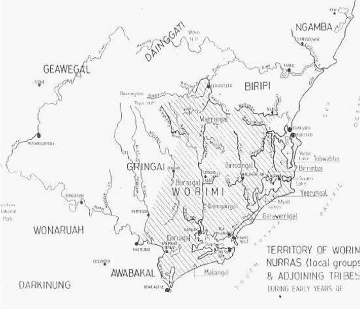
However sadly, each year, thousands of visitors (and locals) leave without knowing about the local Aboriginal people of the Worimi nation, the land within the natural boundary of the Hunter River to the south, the Wallace River (north of Tuncurry) to the north, Barrington Tops and Gloucester ranges to the west, and the Pacific Ocean to the east.
The people of the Worimi nation lived a hunter-gatherer-fisher lifestyle in ten nurra’s (family groups) and would seasonally gather, in and around Hawks Nest, to hold celebrations and ceremonies; make use of the natural resources – water, food and materials for tools; and bury their dead. I am a descendent of the Gringai clan of the Wonnaruah nation and I live on Worimi country. My husband’s family are Worimi/Biripai descendants, and continue to make the most of foods such as Taylor, Bream and Mullet, Crab, Prawns, and plants including Pigface, Lemon Myrtle, Riberry fruits found around Hawks Nest.
On this self-drive tour, I will guide you to a few significant locations and share information about the Worimi people. Our family regularly camps on the edge of Bombah Broadwater Lake, at Mungo Brush Campground, 20km north of Hawks Nest, in the Myall Lakes National Park. Bombah is one of three interconnected lakes that sit on an ancient river basin that are bound by older flatter sand dunes in the west, formed about 60,000 years ago, and higher dunes on the coast, shaped about 6,000 years ago when ocean levels stabilised to the present level.
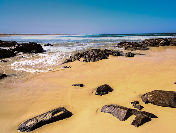
From Mungo Brush campground, our next location is Dark Point, 8.2km away, on Mungo Brush Road heading south towards Hawks Nest. Dark Point car park is signposted, so find a park and take the Dark Point walking trail (figure 3), a moderate 2km return walk over sand-dunes and through an area that contains thousand-year-old ‘middens’ or piles of discarded shells from eaten seafood, and burial sites. At Dark Point beach, a few metres back from the high tide watermark; you can dig a hole in the sand and find fresh water that comes from the ancient underground river basin. When you look east from the beach you see Broughton Island which is 3km offshore (figure 2). The Worimi people tell stories of their ancestors walking to Broughton to hold ceremonies and practice rituals prior to rising ocean levels, then gathering on the beach, near Little Gibber Headland, taking turns to travel by canoe in gender groups, to continue the practices. Tragically, in the 1830’s, this was the site of a massacre of the Worimi people by invading settlers.
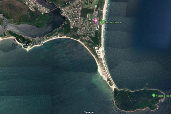
Our next location is Winda Woppa (on Jimmys Beach), Barnes Rock and Mt Yaccaba (see the map above). Travel 15km south toward Hawks Nest, and take a walk on Jimmy’s Beach and head south to Barnes Rock. In the bay south of Barnes Rock there are remnants of ancient tidal rock fish traps that you can still see at low tide. Unfortunately, most of the rocks of the fish trap have been removed and used in the gardens and retaining walls of local non-Aboriginal people. Interestingly there are hundreds of these fish traps all along the NSW coast with another 20 minutes away from Hawks Nest, near North Arm Cove.
At the north end of Jimmy’s Beach is Mt Yaccaba headland. You can access two walking tracks from Jimmy’s Beach Reserve Carpark – one is a 2.9km long moderate walk, the second is a hard 7km return walk. Notice the sandbank that you walk on out to Yacaaba: it used to be a lot wider but narrowed between 6000 and 8000 years ago when oceans rose to their current level. For the Worimi people, much of their environment was consumed by large amounts of water which had a significant impact on their lifestyle and access to food sources. From here, I recommend a swim at the beach, a meal at any of the local restaurants, cafes and a good rest. Take a break and enjoy this magical part of Australia.
Lastly, a note about accommodation. Details of the variety of options available at Hawks Nest and Tea Gardens, can be found at http://www.greatlakes.org.au/. To camp in a National Park you need to book and pre-pay online at www.nationalparks.nsw.gov.au/bookings, and purchase a National Park vehicle pass costing $8 per vehicle per day.
Stephanie Callaghan’s Aboriginal name is Koonjiani. She is from the Goorangai clan of the Wonnarua Nation and lives in Karuah, New South Wales. She works as a preschool teacher while also running her own business as an Aboriginal cultural educator. She is completing a Bachelor of Arts/Bachelor of Teaching by distance mode at Avondale University College.